
Urban Planning
Assessing land use & infrastructure.
Curious about how technology is reshaping our understanding of the environment and our homes? LiDAR, a powerful tool that uses lasers to create detailed 3D maps, opens up new possibilities in property assessment and urban planning.
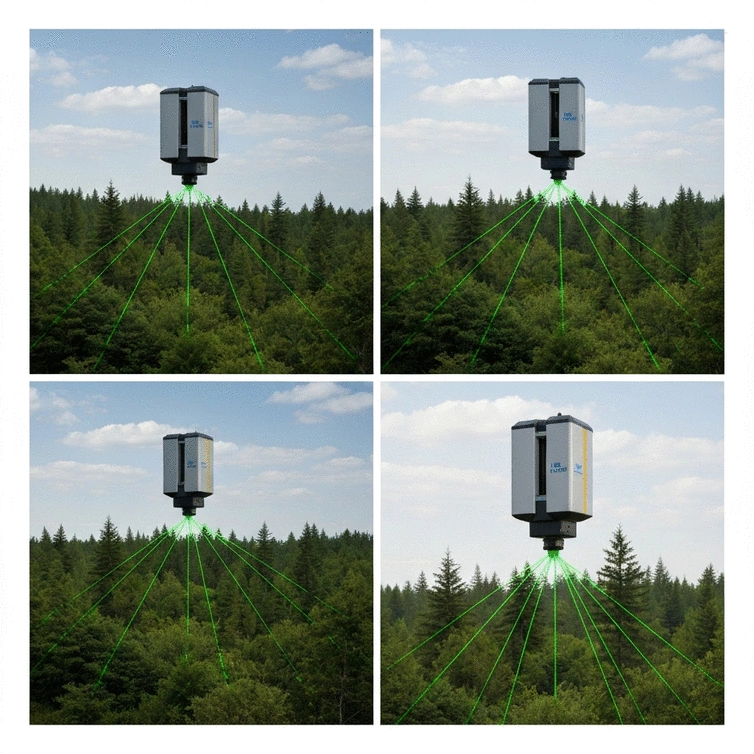
LiDAR technology offers precise 3D mapping capabilities across diverse applications. The visual below highlights its key uses and the two primary types of LiDAR systems.
Assessing land use & infrastructure.
Detailed mapping & biomass estimation.
Modeling networks & road conditions.
Accurate site surveys & progress monitoring.
Covers large areas quickly, high-resolution data for vast landscapes.
Detailed scans of smaller areas like buildings or specific features.
LiDAR, which stands for Light Detection and Ranging, is a cutting-edge technology that utilizes laser light to measure distances and create detailed three-dimensional representations of the Earth's surface. It works by emitting rapid pulses of laser light at a target, which then reflect back to the sensor. This data is collected and processed to generate highly accurate 3D models, making LiDAR a vital tool in various industries.
Understanding how LiDAR technology operates is crucial, especially for those of us at The Homeowner's Compass looking to make informed decisions about property assessments or renovations. The ability to visualize changes to terrain or structure in three dimensions offers homeowners insights that traditional surveying methods simply can't provide.

At its core, LiDAR technology employs laser beams to measure distance. When these beams hit an object, they bounce back to the sensor. The time it takes for the light to return is used to calculate the distance. The resulting data is then processed into a point cloud, which is a collection of data points in three-dimensional space.
This process can occur from various platforms, including aircraft or terrestrial vehicles, allowing for a wide range of applications. From property mapping to environmental monitoring, the potential uses of LiDAR are expansive and exciting!
LiDAR technology has found its way into numerous fields, enhancing capabilities and improving outcomes. Here are some of the key applications:
For homeowners and those considering renovations, understanding these applications can be beneficial. Imagine having precise data on your property’s topography before starting a landscaping project! This knowledge can save time and resources.
Remote sensing complements LiDAR technology by providing additional data sources and context. It involves collecting information about an area from a distance, often using satellite or aerial imagery. When integrated with LiDAR data, remote sensing enhances the accuracy and depth of analysis.
This combination creates a more comprehensive view of the landscape, which can be advantageous when planning renovations or assessing property value. The insights gained through these technologies empower homeowners like us to make informed decisions.
LiDAR systems can be broadly classified into two categories: airborne and terrestrial. Each type serves different purposes and has unique advantages. Understanding these differences can help you determine which might be suitable for your needs.
Choosing the right type depends on the scale of your project. For instance, homeowners looking to remodel or renovate might benefit more from terrestrial LiDAR, while those wanting to understand their property in a broader context might prefer airborne LiDAR solutions.
Did you know? When considering LiDAR technology for your projects, always assess the intended application first. Different LiDAR systems are optimized for specific tasks, such as urban planning, forestry, or construction. By selecting a system tailored to your needs, you can ensure more accurate results and a better return on your investment.
Choosing the right LiDAR tools for your needs can feel overwhelming, especially with the various options available. It’s essential to start by identifying your specific requirements. Ask yourself: What are your project goals? What kind of data do you need to collect? Addressing these questions will help you narrow down your choices.
Here are a few key factors to consider:
By weighing these factors, you can confidently select the right LiDAR tools that align with your project needs!
For small and medium-sized businesses, a sound cost-benefit analysis is crucial when investing in LiDAR technology. It’s not just about the initial costs, but also about understanding the long-term returns. Take a moment to evaluate these elements:
Being thorough in your analysis can ensure that you’re making smart financial decisions that benefit your business's growth.

Understanding LiDAR accuracy and resolution is essential for obtaining optimal results in your projects. The precision of your data can significantly affect outcomes and decision-making processes. Here’s what you need to know:
Ultimately, a clear understanding of these factors will empower you to leverage LiDAR technology effectively, ensuring you achieve the best possible results in your projects.
As you navigate through the world of LiDAR, engaging with the community can provide valuable support and insights. There are numerous resources available that can enhance your learning and application of LiDAR technology.
For those just starting with LiDAR, exploring case studies and tutorials is a great way to learn. These resources often cover:
These insights can help you feel more confident and prepared as you begin your journey!
Utilizing interactive tools and comparison calculators can also aid in your decision-making process. These resources allow you to:
Making informed decisions becomes much easier with these tools at your disposal!
Open-source LiDAR software options can offer great flexibility and functionality for users looking to explore without significant investment. Here are some benefits of open-source solutions:
Exploring these options can enhance your learning experience and possibly lead to innovative solutions in your projects!
As you dive deeper into LiDAR technology, remember that informed decision-making is key to success. The insights and resources discussed here can serve as a solid foundation as you continue your journey.
In summary, we’ve explored essential considerations for selecting the right LiDAR tools, conducted a cost-benefit analysis, and highlighted the importance of understanding accuracy and resolution. Keep these points in mind as you progress!
What challenges are you facing in your LiDAR projects? Asking the right questions and seeking further information can open doors to new insights and solutions. Don’t hesitate to reach out and engage with the community!
The future of LiDAR holds exciting opportunities, especially in fields like environmental monitoring and disaster management. As technology evolves, these applications will become increasingly essential for ensuring sustainability and safety. Stay informed and proactive in your LiDAR journey!
Here is a quick recap of the important points discussed in the article:
Understanding Commercial Warehouse 3D Scans

Are you ready to revolutionize your approach to commercial warehouse projects? The integration of 3D
Explore Industrial Real Estate Virtually

In an age where technology shapes our experiences, industrial real estate virtual tours are transfor
Understanding Pointcloud 3D Data

As 3D technology reshapes our understanding of physical spaces, mastering 3D point cloud data is mor
Understanding Commercial Warehouse 3D Scans
Explore Industrial Real Estate Virtually
Understanding Pointcloud 3D Data
Site Measuring for Architects Explained
Understanding LiDAR Technology Basics